
Where We Fly
How To Find Us
We are blessed with nice open and quiet space in which to fly, however it is not so easy to find for those not familiar with the area. The airfield itself was the original airfield of the Sligo Aero Club, which was formed in 1975 and have since moved to Strandhill (Sligo Airport).
Approximate GPS Co-ordinates: 54.17N 08.55W (+54N 10.2', -8W 32.88')
Loc8 Code: FDK-28-RP9
Contact Numbers: Michael 8712 151 580 / John 0048072680
Check out the Google Map below, you can pan and zoom as required. Scroll further down this page to get more detailed directions:
View Larger Map
While Google maps are handy they can provide you with silly directions just like a GPS leading you down some poor farmers' lane. We have provided detailed directions below depending on where you are travelling from. Once you have found us you will find it easy to remember the way.
From Collooney
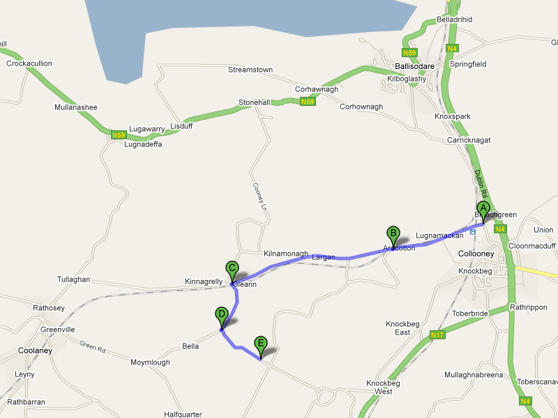
Heading out of Collooney on the Ballisodare road take the first left for Collooney Train Station at
marker A on the map opposite (click on the image to enlarge).
After about 1 mile (1.6km) you will meet a set dangerous bends as you cross over the disused railway at
marker B.
Continue on and turn left at marker C after a further 1.5 miles (2.4km) from B. You can't miss it,
it's the only left turn in the area and you will cross railway tracks only a few meters from the turn off.
Drive on for another half mile (0.8km) and there is a turning left onto a laneway hidden behind a
small cottage that is open to the road at marker D.
Look up and you should see some overhead power lines.
This lane twists and turns for a few hundred yards so be careful.
You will then find yourself driving on the right hand side of a large open field,
our car park is on the right and near the end of this straight at marker E.
From the N59, Sligo to Ballina Road

If you are coming from the Ballina direction then take the turn off for Coolaney at marker A
on the map opposite (click to enlarge)
This is about 1 mile after Collery's shop
(on your right) at Beltra.
You will take the twisty 'Hungry Rock' road over the hill, when the road straightens out take a
left turn at marker B which is 2 miles (3.2km) from A.
You are now heading for Collooney (not Coolaney!).
Turn right after another 1.6 miles (2.5km) at marker C, be careful as you might miss the turn.
Drive on for another half mile (0.8km) and there is a turning left onto a laneway hidden behind a
small cottage that is open to the road at marker D.
This lane twists and turns for a few hundred yards so be careful.
You will then find yourself driving on the right hand side of a large open field,
our car park is on the right and near the end of this straight at marker E.
From the N17, Sligo to Galway Road

Some members take this route coming from Sligo. Click on the image opposite to enlarge.
If you are coming from the Sligo direction then turn right at marker A, this turning is after the
Ballymote turn-off and before the main road narrows (end of the slow lane for oncoming traffic).
If you are coming from the Tubbercurry direction then turn left at marker A, this is a short distance
after Ballinacarrow village. Look out for the turning when the main road widens,
it's at the start of a slow lane.
After the turning, drive for a half mile (0.8km) along the river,
follow the road as it turns right and away from the river at marker B and continue on for
another half mile.
Turn right at marker C, this is a high walled estate entrance but you are on the right road (or lane!).
Drive along this road for about 1.3 miles (2.1km) until you come to a cross roads at marker D,
turn left and you should see the flying strip ahead of you.
The car park is a short distance on the left opposite the entrance gate.